Many are the woes of a keen rambler who doesn’t know how to use a compass. Whether it is the reluctance to explore the path less taken in a no-mobile-network area or being the group simpleton in a team of full of veteran ramblers, it is not fun being ‘that’ person. ‘That’ person could be the one getting ‘simplified’ instructions at de-briefing dinners or he/she could be the one that the Mountain Marshall distrusts! Don’t believe me? Let me narrate an incident.
Around mid-summer I took on the 3-peak challenge – climb 3 of the highest peak in the UK within 24 hours. Two of the ‘must-brings’ in the equipment list was a compass and a map. I argued that those items will only add to the weight in my bag without serving any other purpose. The Mountain Marshall decided that I was an enemy! He did remember, though, at the de-briefing dinner to keep instructions simple. “In case you separate from the group and get lost, keep going northwest and you are bound to hit the right trail”. Then, catching the Garfield-look from me, he goes ‘walk compass needle pointing top left!’ See what I mean?
So no points for guessing my reaction when I saw the Surrey Hills Navigation Walk advertised in the Newsletter. It was a sign – the universe was telling me to overcome my navigation disability.
After waiting for, what to me seemed like forever, D-day, July 2, dawned bright and sunny. A small group of friendly people under Pete’s leadership met at the Chilworth station. Starting from the Station, the group was paired up and it was decided that each of the pair take turns to lead. Each team of two was assigned the co-ordinates and it was their responsibility to figure out the path and get from Point A to Point B. Although this was a follow-up walk to a theoretical meet-up last February, absolute newbies like me (I only became a member at the end of June 2014) were given due guidance in understanding some of the map’s features and legends. Needless to say, it was one of the most interesting of walks I had done recently. The comradeship that comes out of knowledge sharing and information consulting can be quite stimulating. It keeps you encouraged, energised but mostly involved.
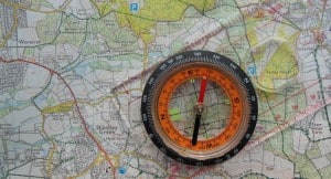
To me, as someone, who is keen on improving directional abilities, the best part of the walk was when we stopped on Blackheath to get our bearings. Standing there in a heath, setting the map with the compass so that it matches what you see in the distance and trying to point it in the right direction was quite interesting. We had the St Martha’s Church (yes the one at St Martha’s Hill, what an incredible sight) in the distance which we used to identify our position with, adjust the Magnetic North and Map Grid North and then decided on the direction of the path that would take us to our pre-designated spot.
At the end of the walk, I was, as they say ‘well chuffed’!
As a new member, I am keen to see unique and interesting Walks like these.
Can’t wait for Pete to organise another such walk. Come rain or shine I will sign up!
Editors Note: The author of this article – Supriya – is a young Indian lady who is working in Surrey at the moment. She comes from a family background where walking in the country is not regarded as “safe” so the concept of walks in the Surrey Hills is inspirational for her. She has recently joined the Society, and taken part in a number of our 20’s to 30’s events and others from our mainstream programme. Supriya is an excellent ambassador for the Society and shows the way that we can help people to explore and appreciate our special Surrey Hills.